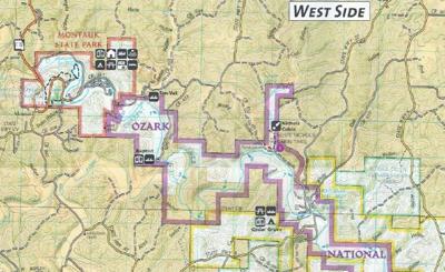
The National Park Service has released the Ozark National Scenic Rivers Roads and Trails Management Plan. It is now open for comments and that comment period ends July 18. Those concerned about access to the Current River, either by vehicle, horseback or ATV/UTV, need to review this plan and provide comments before the deadline.
This proposed plan is going to designate what roads and trails are available for use by the public. All “undesignated” roads and trails will be removed and will not be usable by the public in the future. All of the proposed alternatives to the plan will substantially reduce what is currently available to the public (and what the public has been using for years).
The goals of this plan are to establish:
(1) a system of designated roads, trails, public recreation areas, and staging areas;
(2) appropriate types and levels of visitor use associated with roads and trails;
(3) maintenance standards for designated roads and trails; and
(4) guidance for restoring roads and trails identified for closure or rerouting.
Plan 1.2.1. The cultural objectives state that roads, trails, river access points, and river crossings would be located to avoid and/or protect cultural resources that are important and integral to understanding the human history of the area.
Plan 1.2.2. This means the Park Service wants to limit access to cultural resources of local significance (e.g., there are no proposed roads or trails to Schafer Springs Lakes on this proposed Plan even though those proposed roads appeared on prior versions of the Plan.). Roads, trails, river access points, and river crossings would be designed and located to maximize the efficiency of maintenance, interpretation, resource management, and law enforcement efforts while minimizing financial costs.
Plan 1.2.5. Stated differently, miles of existing roads and trails would be eliminated to ease the maintenance and policing burden on the National Park Service.
Finally, and least important to the National Park Service, community objectives for the plan state the park’s network of roads, trails and recreation facilities would reflect the importance of the Current and Jacks Fork rivers to communities and the surrounding region, both in terms of economy and lifeways. Plan 1.2.6. I.e., granting access to local people who enjoy the river and economically rely on the river.
Management issues identified by the National Park Service, which they believe necessitate this Plan, include the following.
First, the proliferation of undesignated roads and trails (e.g., over 39 miles of roads used mainly by ATVs and UTVs and over 90 miles of horse trails, many of which are “unauthorized, visitor-created trails” – that is, trails not approved by the Park Service that were created by local residents). The Park Service specifically attributes this to “an increase in the popularity of horseback riding in and around the park during the last few decades.” Plan 1.4.1.
Second, the lack of clearly defined, designated trails has also made navigation in some areas difficult and confusing for park visitors. Specifically, making it more dangerous for visitors and more difficult for “law enforcement personnel and more complex search and rescue operations.” Plan 1.4.2.
Finally, the park service identifies natural and cultural resource considerations. Specifically, “the use of undesignated roads and trails fragment larger areas of quality habitat resulting in smaller, less effective islands of high-quality habitat throughout the park. In addition, the current volume and location of undesignated road and trail crossings in the Current and Jacks Fork Rivers can have an adverse impact on water quality and the Ozark hellbender.” Plan 1.4.3.
While it may be true that four-lane highways create islands of habitat, these gravel roads and horse trails do not create islands of habitat. In short, the park service doesn’t want anyone using roads around the river and they certainly don’t want anyone in the water.
The park service has offered three alternative plans.
The first plan is no action, which means they do nothing and all of the undesignated roads and trails will remain illegal to use. In short, the park service isn’t designating any roads. Mind you, these roads and trails already exist and are currently being used by everyone – they just aren’t approved by the park service.
Alternatives B and C are progressively designating more roads and trails. In the most generous alternative offered by the Park Service, Alternative C, the NPS would close about 11 miles of existing roads and close over 30 miles of horse trails (park service would designate about 61 miles of trails, including 10 miles of trails outside the ONSR). Remember, there are over 90 miles of existing horse trails. Plan Chapter 2. Any proposed alternative will substantially reduce the roads and trails available, but Alternative C offers the most roads and trails.
Further, under Alternatives B and C, the NPS is implementing bicycle trails and will require permits for horse riding and riding ATVs and UTVs. See Chapter 2 of Plan. The primary aim of this plan is to reduce the number of people using the Current River and surrounding land. The park service plans to do this by eliminating access to the river and surrounding lands by removing roads and trails that are currently being used. This will not limit the number of people using the land, just concentrate those people into certain areas. The park service will limit the number of horse riders and people using ATVs and UTVs by limiting the number of permits available. This likely will be similar to their voucher system for canoe venders. There are a limited number of permits, so the number of users is thereby limited.
On Page 72 of the plan, the NPS finally admits this plan will mostly affect local residents: “the closure of undesignated roads would largely affect local visitors who are the main users of these roads. These closures are not anticipated to affect nonlocal visitation, and changes in visitor spending and associated regional economic impacts are expected to be negligible compared to the no-action alternative.” Plan 3.8.3.
In a letter to the U.S. Fish and Wildlife service in 2019, the park service summarized this plan:
“Most of the undesignated, visitor-created trails would be closed and restored to natural conditions. The National Park Service would seek to establish a permitting system for equestrian users that would provide information and education to riders, track the volume of use on equestrian trails, and help the park manage the levels of use on equestrian trails. All undesignated roads would be closed and restored to natural conditions. Undesignated river crossings and vehicle fords would be reduced from current levels to minimize potential impacts to water quality and other sensitive species and resources.” Plan page 193, Letter dated October 17, 2019 NATIONAL PARK SERVICE to Karen Herrington, Field Supervisor U.S. Fish and Wildlife Service.
When a federal agency like the park service wants to change or create new rules and regulations they are required to get public feedback on their proposed changes before taking any action. Further, they must take those comments into consideration when making their decisions. If people don't comment, the park service will make whatever decision it deems fit, which is to substantially reduce vehicle and horse travel in and around the Current River. Their ultimate goal is to substantially reduce the number of people using the Current River and surrounding lands.
It is extremely important that interested parties comment on these proposed rules, because once they are in place, the National Park Service will start writing tickets to people for violating the rules (e.g., driving vehicles or riding horses on unapproved roads or trails). These tickets are particularly burdensome to local residents because these cases won’t be in a local court, but rather in Federal Court in St. Louis.
Around 1,000 people commented in the two prior comment periods. So, if a good number of people comment during this comment period, it can have an impact on the management plan. Everyone that is interested in accessing the Current River needs to comment on the proposed plan. Interested parties should be specific and explain how using a particular road or trail is important to them. Further, comments need to be intelligent, well-written and concise. This plan will affect people accessing the river by vehicle, horseback, and ATV/UTV. So, those concerned about how that is going to happen need to comment before July 18.
The draft ONSR proposed trail plan with options is available at the Salem library and online at https://parkplanning.nps.gov/document.cfm?parkID=158&projectID=56591&documentID=113284. The link to provide comments is https://parkplanning.nps.gov/commentForm.cfm?documentID=113284.